|
Copyright ©2009 by Paul Niquette. All rights reserved. |
|||||||||||||||||||
 The plan for
what was intended to be the second-to-last leg
of Amelia Earhart's round-the-world adventure
included... The plan for
what was intended to be the second-to-last leg
of Amelia Earhart's round-the-world adventure
included...
{2} Take-off on a Primitive Runway at Lae ~~~~~~~ 10:00 AM Local Time {3} ETE to Howland Island, 2,556 statute miles away ~~~~~~~~~ 18 hours {4} True Heading for the Route ~~~~~~~~~~~~~~~~~~~~~~~ 78 degrees {5} Winds Aloft Forecast ~~~~~~~~~~~~~~~~~~ ENE at 15 miles / hour {6} Fuel on Board at Departure ~~~~~~~~~~~~~~~~~~~ 1,100 gallons {7} Estimated Fuel Consumption Rate ~~~~~~~~~~~ 50 gallons / hour 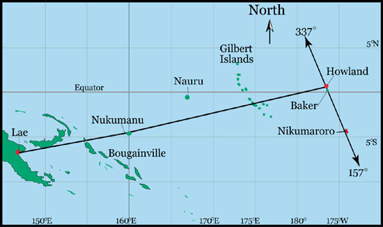 TIGHAR Earhart Project used by permission
In planning the flight, Navigator Fred
Noonan would have determined the Point
of
No Return.
Over
the decades, plenty of speculation has accumulated about
where Amelia Earhart's flight actually ended. The
most credible locations, based on her final radio
transmissions, are within a couple hundred miles of
Howland, including this one.
Others call for radical off-course routes or, as in this
one,
a course-reversal toward Lae. The Point of No Return puzzle is
based on speculations about Fred Noonan's flight
planning not on potential locations of
crash-sites. |